Photos and texts taken from www.openalpmaps.it/progettodolomia
The Dolomia Way - The journey of the rock in the Dolomite Alps
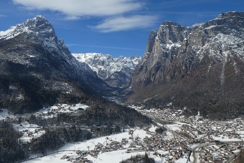
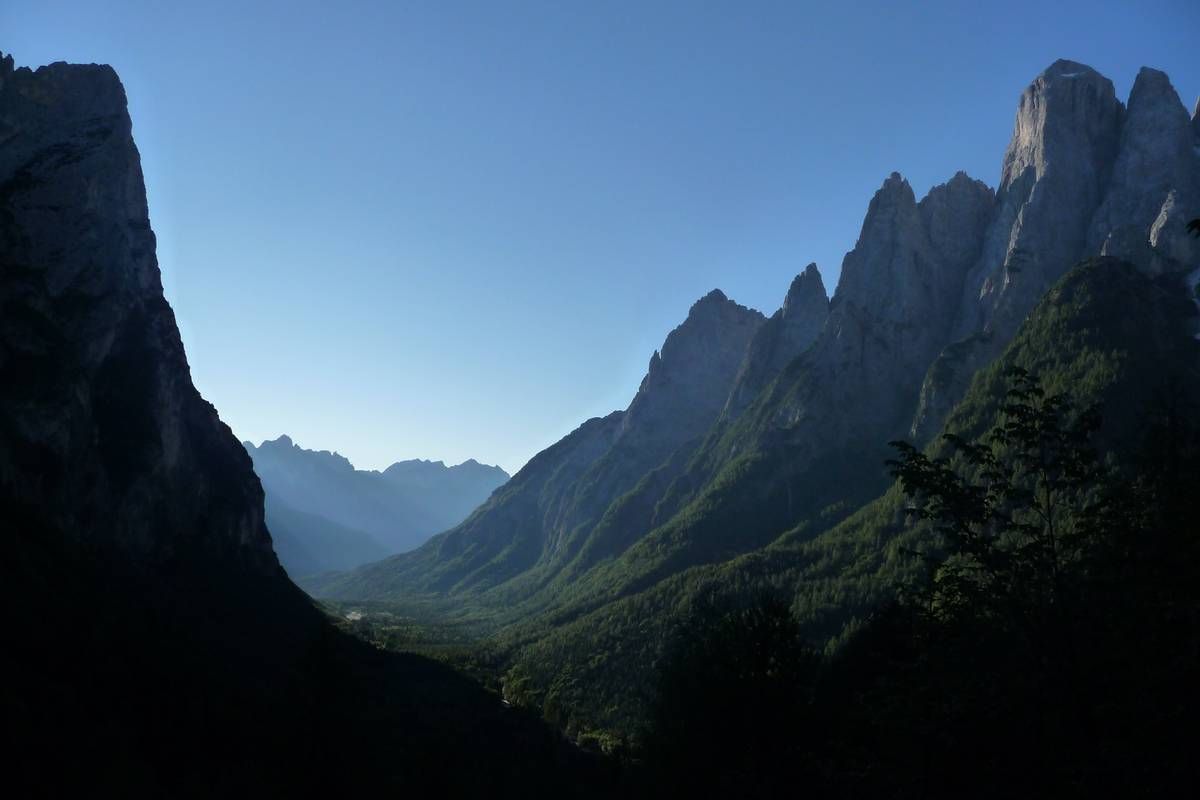
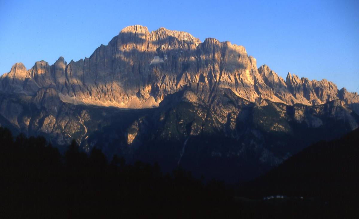
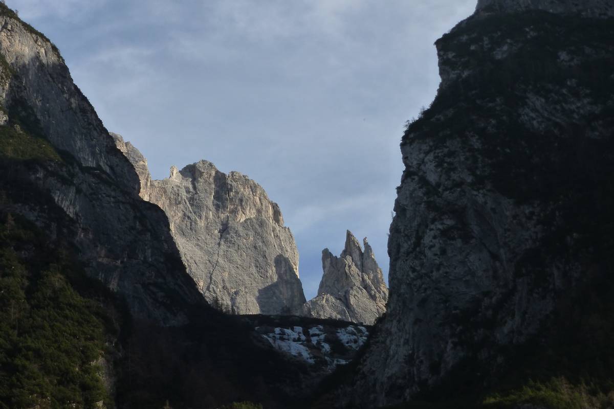
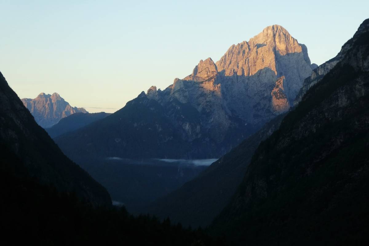
San Lucano Valley
The San Lucano Valley is 10 km long with an average width and depth of almost 2 km. It crosses the core of the largest of the Dolomite cliffs and retains a clear glacial imprint. In the Tegnàs basin, carbonate and detrital sedimentary rocks and intrusive and effusive magmatic rocks are placed side by side to form a unique place.
The valley is enclosed to the south by a series of jagged peaks that culminate with the north edge of the Agnèr, the highest wall in the Dolomites. To the north, it borders with the 1300 meters of straight and protruding rocks of the Pale di San Lucano, cut through by deep rocky abysses. It seems to end up against the Pale di San Martino plateau, but in reality, a huge glacial cirque surrounded by vertical ridges continues with the Val d’Angheràz. Here the peculiarities of the Dolomite landscape reach their maximum expression with horizontal lines of ledges and plateaus, perpendicularly intertwined with towers and gullies.
With the verticality of the walls comes different shapes (thin picks, majestic towers, imposing bastions) and colors contrasts: dolomitic rocks painted by the sun’s rays next to dark volcanic rocks. In addition, the monumentality of the immense obelisk of the Agnèr and the agile Armenian Tower contrast with the square building of the Pale.
Few places evoke the sense of the sublime like this Valley, whose vertical and looming walls leave a pleasant sense of bewilderment and fear, especially when the storm clouds creep between the towers and rise the “borai” (narrow and deep rocky gullies), making details otherwise invisible stand out.
The valley is very rich in geological, landscape, environmental, and historical peculiarities and, thanks to the verticality and the height of its walls, it allows to carry out both the usual hiking and sports activities, and extreme sports, such as high-difficulty climbing, canyoning, base jumping, and wisbase.
The riverbed of the Tegnàs
Unlike most of the Dolomite streams, the Tegnàs is a watercourse characterized by a low anthropogenic impact and is free to wander into the valley in a completely natural way. This characteristic has made it an ideal stable open-air laboratory to study the dynamics of river processes. The research, which began ten years ago and is still ongoing, is carried out by the CNR of Milan in collaboration with the IIS “U. Follador” of Agordo.
The analysis of the water flows of the Tegnàs stream highlighted an anomalous hydraulic behavior of the San Lucano Valley. Under normal conditions, the water coming from the upper part of the basin (Val d’Angheràz and Val Bordina) is partially absorbed in the enormous alluvial mattress present in the Mezzavalle area (thickness 150-200 meters, width 300 meters) and it then re-emerges more downstream. The cause of the anomaly is connected to the presence of a buried impermeable septum (a moraine or deep slope collapse) which acts as a regulator of the outflows by dividing the basin into two parts: upstream, there are high, but variable flow rates and large volumes of debris mobilized, while downstream there are minor and regularized outflows with little solid transport. Of course, this behavior does not apply to exceptional events such as the 1966 flood or the Vaia storm, which completely twisted the riverbed.

Geological itinerary of San Lucano Valley
Because of its length of approximately 30 km and its overall difference in the level of over 1500 meters uphill, it would be advisable to divide the itinerary into several different parts to be covered over several days rather than trying to tackle it in a single day on foot.
The part of the route that runs along the valley axis can be crossed either on foot, by bicycle, or by car. If you intend to visit only the upper part, it is advisable to start from Col di Prà, where you can leave your car in the large parking lot.
The itinerary described can be divided into several sections according to the needs and expectations of the user. We suggest 4 themes:
- Water Trail
- Earth Trail
- Fire Trail
- Air Trail
Water Trail:
water in its different aspects, such as streams, springs, waterfalls, lakes, glacial morphology
The path unfolds mostly along the bottom of the valley and can be divided into the following stages: Le Peschiere, San Lucano, Mezzavalle, Col di Prà, Sorgenti del Tegnàs, Cascata dell’Inferno, Pont.
Departure: Taibon Agordino
Length: 10 km
Altitude difference: about 600 meters
Travel time (on foot): one day
Fire Trail:
magmatic stones
For the most part, it follows the bottom of the valley and is divided into the following sections: San Lucano, Mezzavalle, La Calchera, Sentiero Cozzolino, Frana di Prà e Lagunàz, Col di Prà, the “U” section, Pont.
Departure: Taibon Agordino
Length: 9 km
Altitude difference: about 550 meters
Travel time (on foot): one day
Sentiero del Fuoco:
le rocce magmatiche.
It develops entirety through the sub-basin of the Bordina stream, within an area of outcropping magmatic rocks. It is divided into the following stages: Pian della Stua, Casera Campigat, Casera ai Doff, Malgonera, Val Granda.
Departure: Col di Prà
Length: 12 km
Altitude difference: about 1200 meters
Travel time (on foot): one day
Air Trail:
the panoramic views
It’s the itinerary along the ridge between the San Lucano Valley and the Val Garés and is divided into the following stages: The “U” section, Casera Campigat, and Casera ai Doff.
Departure: Col di Prà
Length: 12 km
Altitude difference: about 1200 meters
Travel time (on foot): a whole day


From Listolade Panel 18 (approx. 680 meters above sea level), it is advisable to continue by car to Capanna Trieste Panel 19 (1105 meters above sea level), as in the first section of Val Corpassa there are no important geological features and walking all the way would require you to tackle a challenging altitude difference (about 1200 meters).
Once you have reached Capanna Trieste (Panel 19), you can park in the large parking lot.
It’ll take you about 5 hours to complete the route (round trip from Capanna Trieste).
From Capanna Trieste, take the CAI path n. 555 along the private road of the Mussaia: we are on the path of the legendary “Transcivetta”, a mountain running race in pairs that takes place every year in July since 1980.
After passing a small bridge, the road climbs steeply through the stony wooded slope and then crosses a large active debris flow coming from the Giaroi del Palanzin. To the north, you can see a small waterfall: cross the stream on a bridge and reach an area very rich in water. After 20 minutes of walking, you will then reach Panel 20.
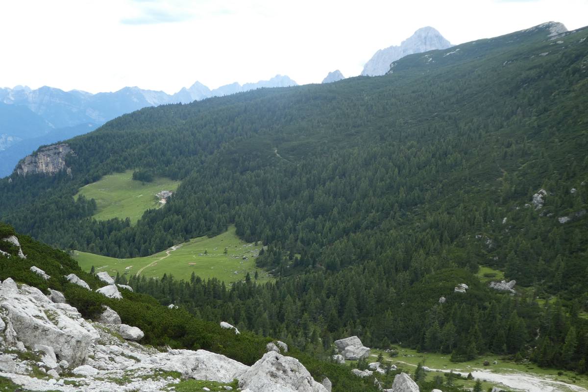
The path continues along the Mussaia road. While you keep climbing, the panorama becomes wider and wider as you reach Panel 21, where you can observe the U-shaped glacial valley profile of Val Corpassa with the left side occupied by the enormous detrital stratum developed at the base of Moiazza and affected by conspicuous phenomena of debris flow.
By continuing the path, you reach Pian delle Taie (approx. 1600 meters above sea level): from here you can see the articulated skyline of the Cantoni di Pelsa. After crossing the stream coming from the Val dei Cantoni, continue towards the Vazzoler Refuge (alt. 1713 m a.s.l., about 1 hour and thirty minutes from Capanna Trieste).
From the Vazzoler refuge, Panel22, take the CAI path n. 560 which, out of the wood, enters a landslide macerate with large boulders formed following a collapse that in 1917 affected the western flank of Torre Venezia. Panel 23 is located here.
From panel 23, continue the path that climbs steeply among the dolomite boulders, in front of Torre Venezia, up to 1800 meters altitude. Once you reach the bend, leave the CAI path n. 560 and take the road that leads to Malga Pelsa, bypassing the Col del Camp.
The site of Panel 24, a fascinating panoramic point, is located on the bend where the road leading to Case Favretti branches off, about a half-hour walk from the Vazzoler Refuge. Continuing for about ten minutes, you reach Malga Pelsa (Casera di Pelsa, 1829 m a.s.l.), where the last panel (n° 25) of the itinerary is located.
“However, we could not pass Listolade without stopping for a minute to take a look into the Valle della Corpassa, which opens on the left of the Cordevole. A mountain colossus, a canvas of naked rocks, closes the background. Have you ever seen a more beautiful or hideous mountain? It is the Civita, also called Corpassa, seen from noon, more like an immense ruined wall than a mountain”
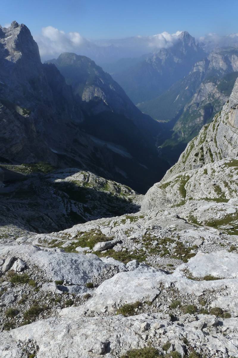
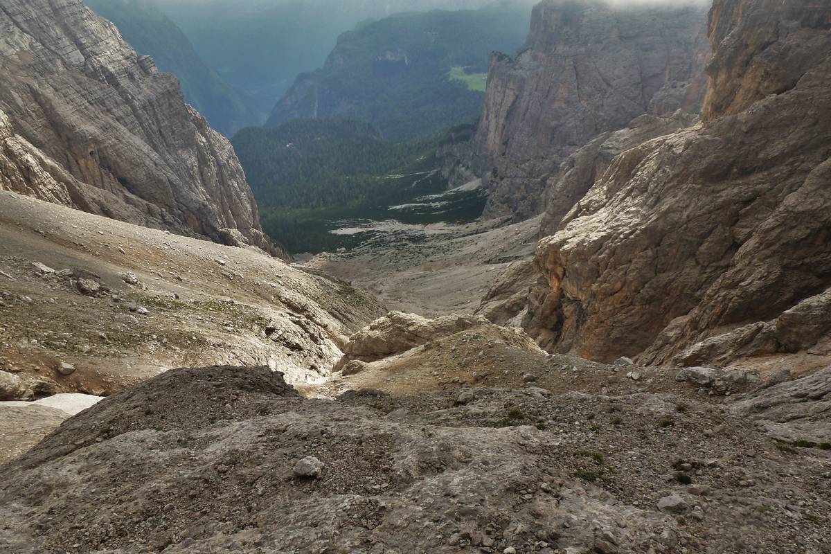
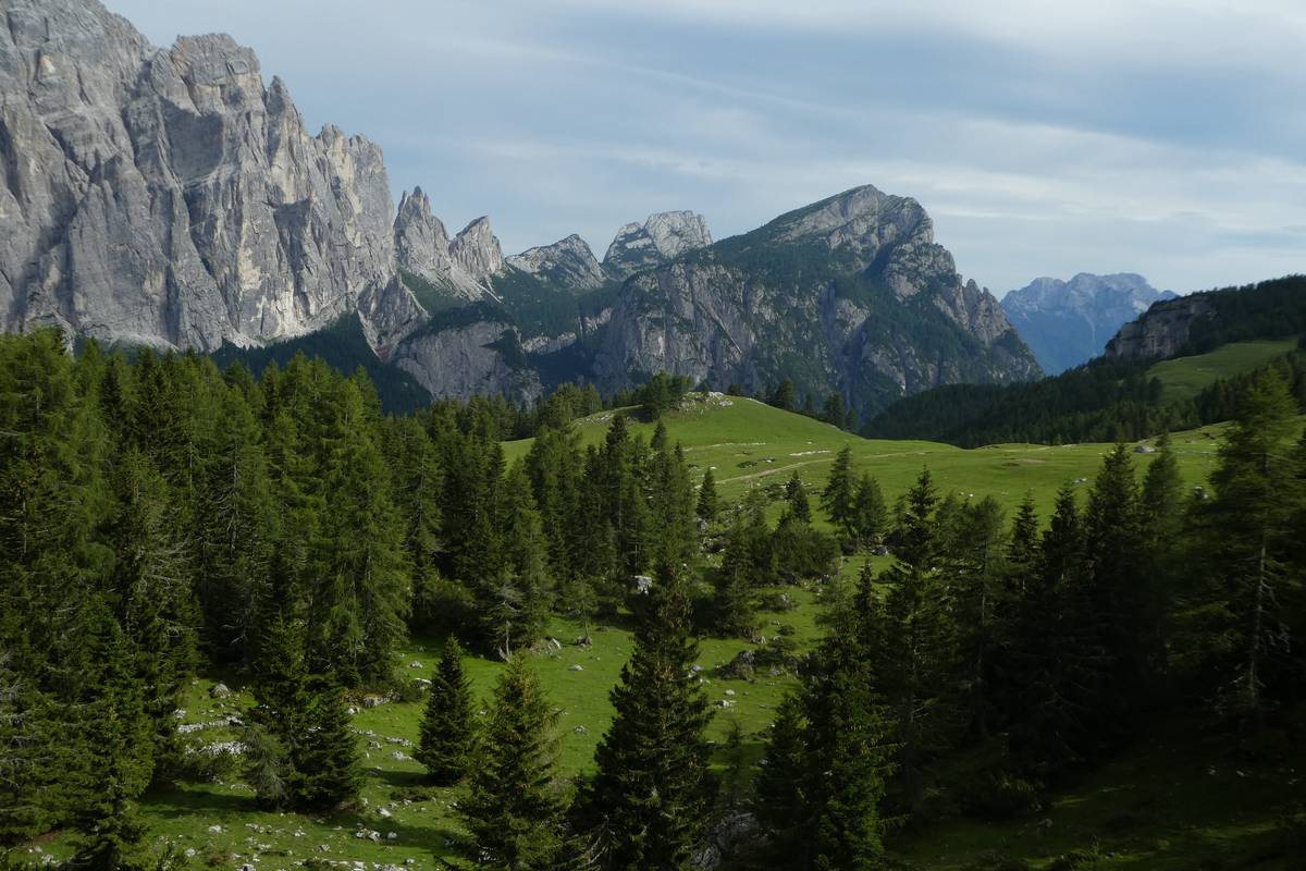
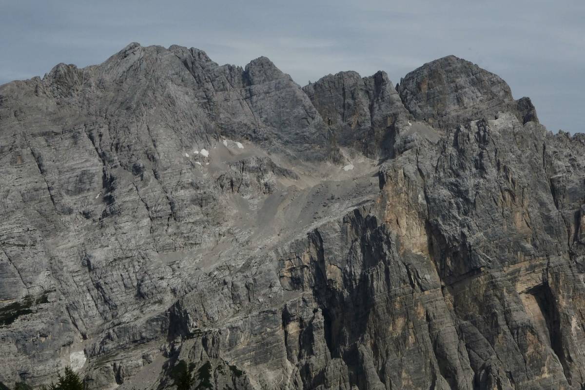
Val Corpassa
Val Corpassa is a deeply embedded furrow in the lower building of the Civetta: at the beginning of the valley, the Werfen Formation emerges for a few meters. At the base of the intake structure (500 meters from Listolade), you can see some layers belonging to the Agordo Formation. After crossing the first one (Ponte di Rabul, 814 m a.s.l.), the road runs over groundwater debris and landslide. The “U” shape of the glacial valley is still recognizable in some sections, even if the valley is characterized by dynamic slopes and the Corpassa stream flows in a particularly unstable riverbed, scattered with huge blocks and boulders.
The surrounding walls are made of the Contrin Formation on the bottom part and by the Sciliar Formation on the top part. Their appearance is not particularly “dolomitic” because the biological alteration at low altitude is very strong, and the rocks are coated with dark patinas.
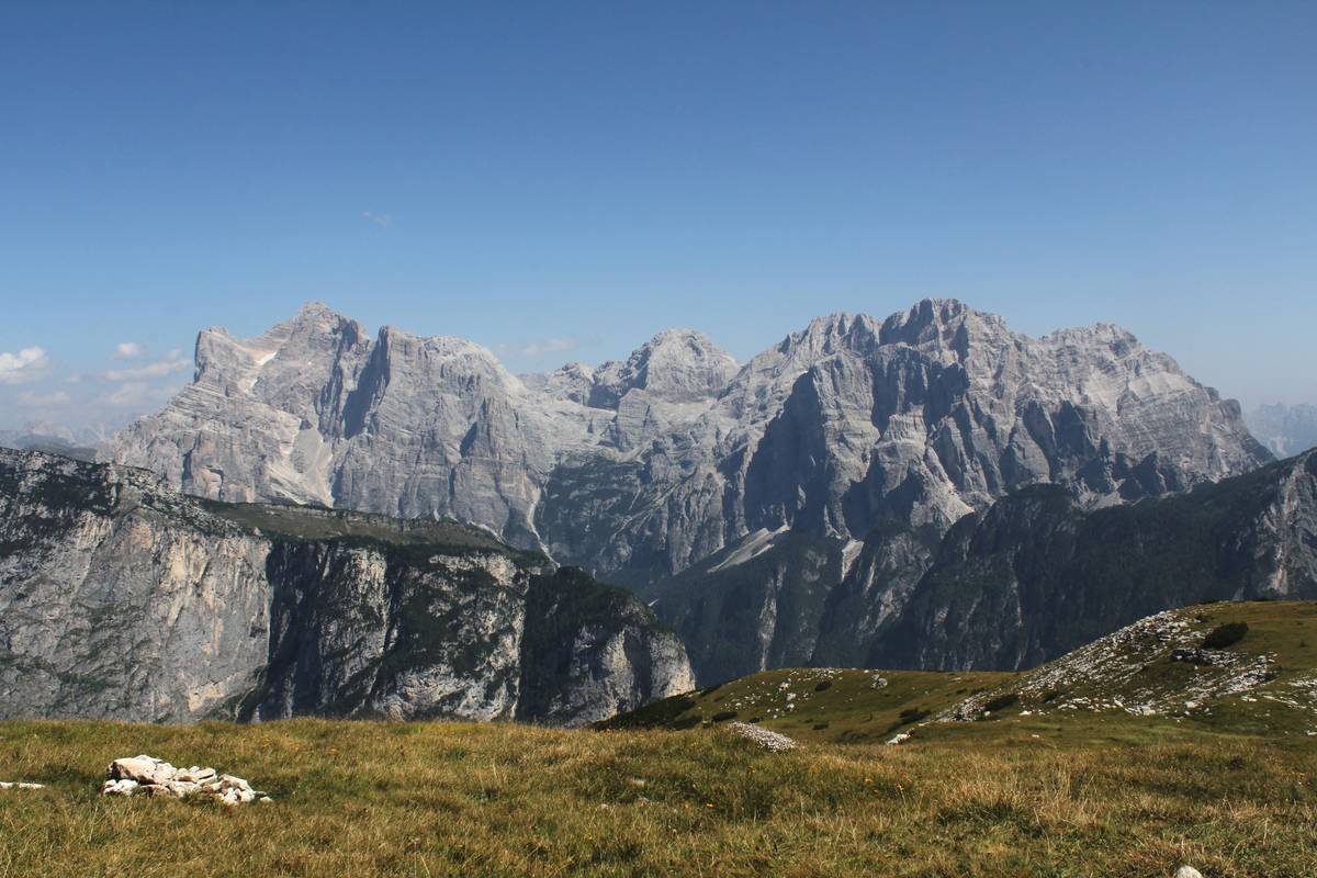
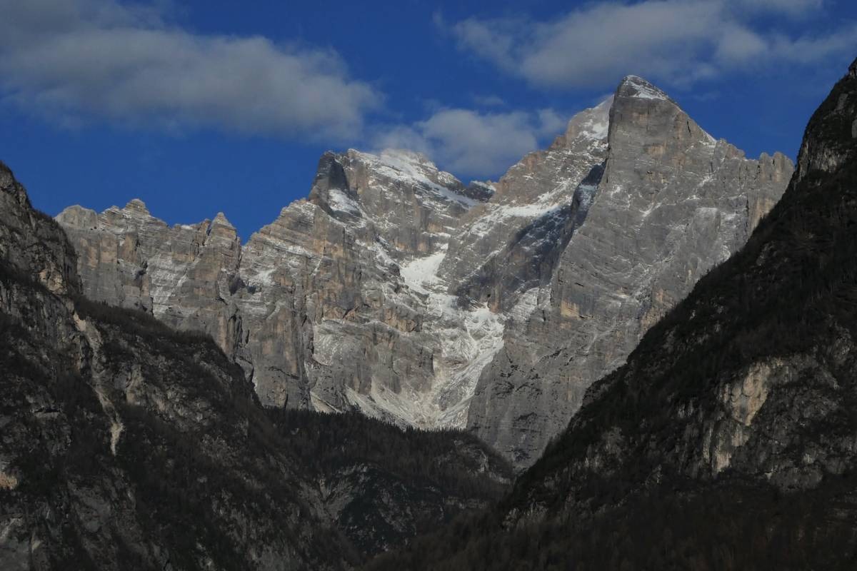
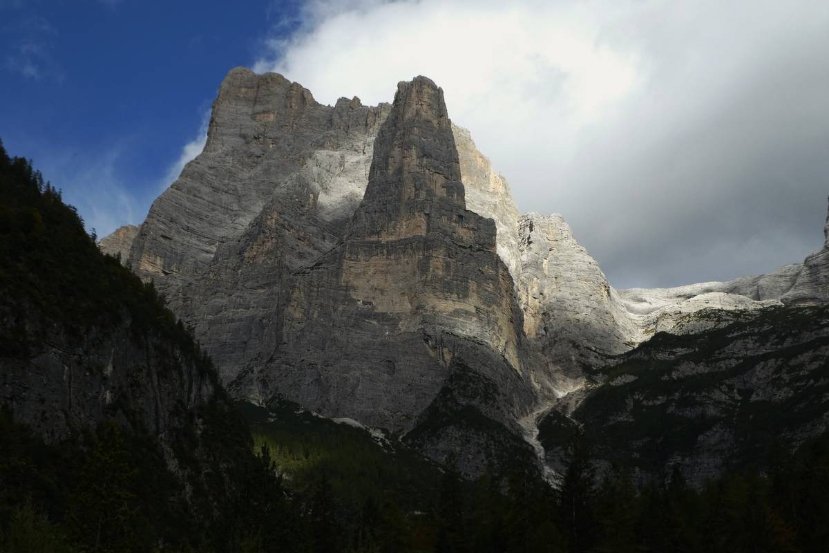
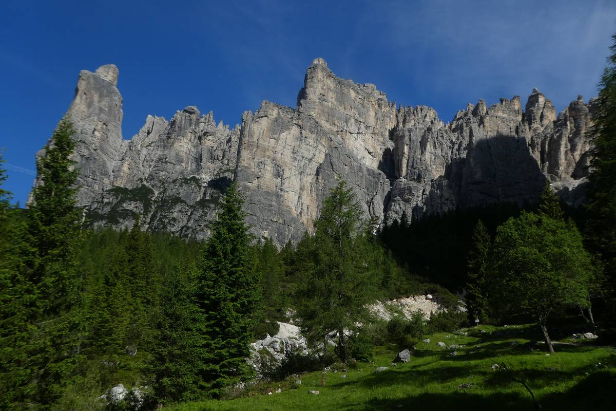
The Civetta Group
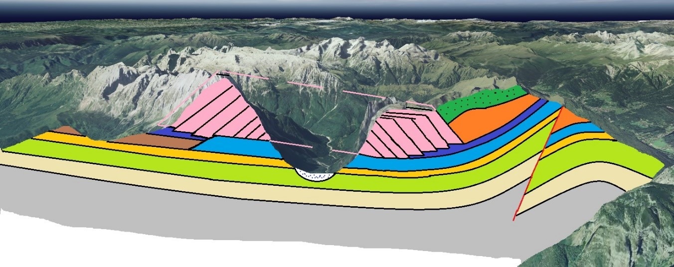
The Dolomites represent the archetype of a particular type of landscape called the “Dolomite landscape”, also present in other parts of the world where, however, it does not reach the splendor, the grandeur, and the power of our mountains. The Dolomites are a serial property consisting of a set of mountain systems that have common features but are distinguished from each other by their particular characteristics. A system is made of one or more mountain groups, and it is difficult to find in a single mountain (except for the Civetta) all the characteristics that have made the Dolomites a World Heritage Site.
In the Civetta Group, the peculiarities of the Western Dolomites (characterized by compact cliff dolomites) coexist with those of the Eastern Dolomites (distinguished instead by stratified dolomites of tidal plain and Liassic limestones). The geological complexity is high and derives from the combination of the articulated Ladin-Carnic paleogeography and Alpine polyphasic tectonics.
The Civetta is an extraordinary mountain, where the immensity of the North-West wall, known in the Germanic world as “die Wand der Wände”, the wall of the walls, 7 km long and 1200 meters high, contrasts with the multitude of towers who embroider the crests. Behind an apparent simplicity lies a complex and articulated series of ridges that enclose sparkling and little-known pearls, such as the Giazér, a small hanging glacier nestled in the upper Val dei Cantoni, among the highest peaks of the group.
The structure of the landscape, the verticality combined with the grandeur of its walls, and the variety of shapes and colors make the Civetta “the natural monument to the Sublime”, the synthesis of all the Dolomites.
The Civetta-Moiazza massif has two parts. The lower building is modeled in the cliff dolomites (Dolomia infraraibliana degli Autori) and separated from the upper one, sculpted in the Main Dolomite and Gray Limestones by the Travenanzes Formation, almost completely covered by groundwater debris.
The more distinctly dolomitic aspect of the upper building essentially depends on the different altitudes: the Main Dolomite and Gray Limestones are located in an altimetric zone in which cryo-nival phenomena prevail. The Dolomite layers belonging to F. del Contrin and F. dello Sciliar are instead located in a climatic area where the effectiveness of chemical-biological processes has led to an alteration of the rock with darker colors than at higher altitudes.


Capanna Trieste
Capanna Trieste is located next to the large stone bed of the stream, near an active detrital gully. The surrounding rocks belong to the Sciliar Formation visibly altered by vegetation, above the slender shape of Torre Trieste (2458 m), 800 meters of a vertical wall with Cima della Busazza (2894) on the left, 1100 meters of wall, and on the right the threshold of the Van delle Sasse and the Cima delle Sasse.
Torre Trieste is half sculpted in the Main Dolomite, the Busazza in the lower part in dolomite, and, at the top, beyond the interruption of the slope, in Gray Limestone. The Val dei Cantoni still hosts a small glacial valley (el Giazer or Glacier de Gasperi), another glacier-snow covered largely with the debris is located on the Van delle Nevere, at the base of the Moiazza.
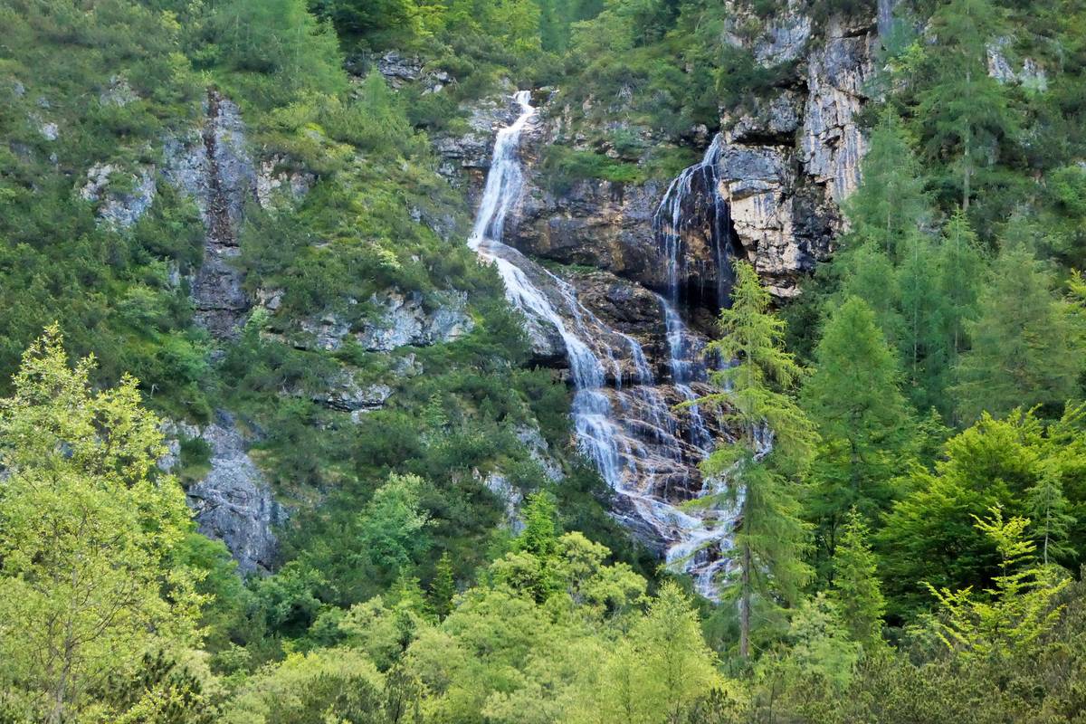
Waterfalls and Karstic springs (1390 m a.s.l.)
This area is characterized by the presence of several Karstic springs. The upper building of the Civetta is made up of Main Dolomite and Gray Limestones, carbonate rocks, and, therefore, it is subject to the karstic phenomenon. The rainwater descends through the cracks in the rock mass, amplified by the action of karstic corrosion, and penetrates deeply (aquifer) until it meets the layers of the Travenanzes Formation. In this formation, characterized by impermeable marly levels (with a high clay content), the water permeated through the fractures and, once reached the dolomite-marl passage, re-emerges on the surface, creating the band of springs.
 Waterfalls and potholes
The waterfalls are certainly one of the most appreciated morphological elements of mountain landscapes. They are found with some frequency in the upper segments of the watercourses in correspondence with jumps developed in more tenacious rocky levels (selective morphology) or the terminal sections of the lateral valleys in correspondence with the rocky thresholds of the suspended glacial valleys. The so-called “evorsion potholes” often develop at the base of the waterfall, especially in the presence of sub-horizontal rocky layers. Locally we call them vasche, cadini, or boioni. The potholes are characterized by a roughly hemispherical shape, with the edge recessed to the hole below. They were dug by the swirling motions of the water and the debris it transported. Karstic corrosion plays an important role also in the evolution of the pots modeled on carbonate rocks.
Debris flows
On the left orographic side of Val Corpassa, at the base of the Moiazza walls, there is a large detrital strip often subject to instability: we are in the presence of a beautiful example of active debris flows.
Debris flows are extremely mobile mixtures of sediments with dimensions ranging from clay to blocks and boulders. Solids can make up to 90% by the weight of the moving mass.
In the presence of intense precipitation or large water flows, debris flows are generated due to an abundant surface runoff concentrated in the gullies, able to remobilize the debris present at the base of the rock wall. The debris flows begin with small landslides that, as they move, increase in porosity and are enriched with water. The incorporation of large amounts of debris in the surface runoff leads to the formation of a solid-liquid current. A phenomenon halfway between the landslide (the moving material flows on a buried surface and stops when the friction between the moving mass and the surface on which it flows exceeds the active component of gravity) and the flood of a course of water (the liquid current erodes and transports sands and silts in suspension and gravels and pebbles on the bottom).
In the landslide, the solid part prevails; in watercourses, the flow rate is above all liquid; in debris flows, the solid/liquid ratio is close to unity.
The debris flows are characterized by waves that show a steep front where the coarser materials (boulders and blocks) are concentrated, followed by a more liquid tail. Subsequent waves may form due to temporary obstruction of the canal and subsequent rupture of the debris dam. They involve permanent channels or open slopes with steep slopes of 15-30°. During the flow, the density varies from 1.8 to 2.5 t/m3 and the speed from 0.5 to over 20 m/s; if the presence of clay is consistent, the debris flows can flow even with weak slopes (up to 5°). The flow occurs at the bed-debris contact, and above a rigid block of debris (plug) is created. An interesting fact is that the largest boulders tend to float.
Also here the morphological elements that characterize the areas subject to debris flows can be easily distinguished: at the top, the trigger zone (scarcely vegetated, steep, with the presence of loose debris), the transport zone consisting of the channel that deepens due to erosion at the passage of the debris flow and the deposit area formed by the torrential fan (in this case, part of the collapsed material was eroded by the Corpassa stream).
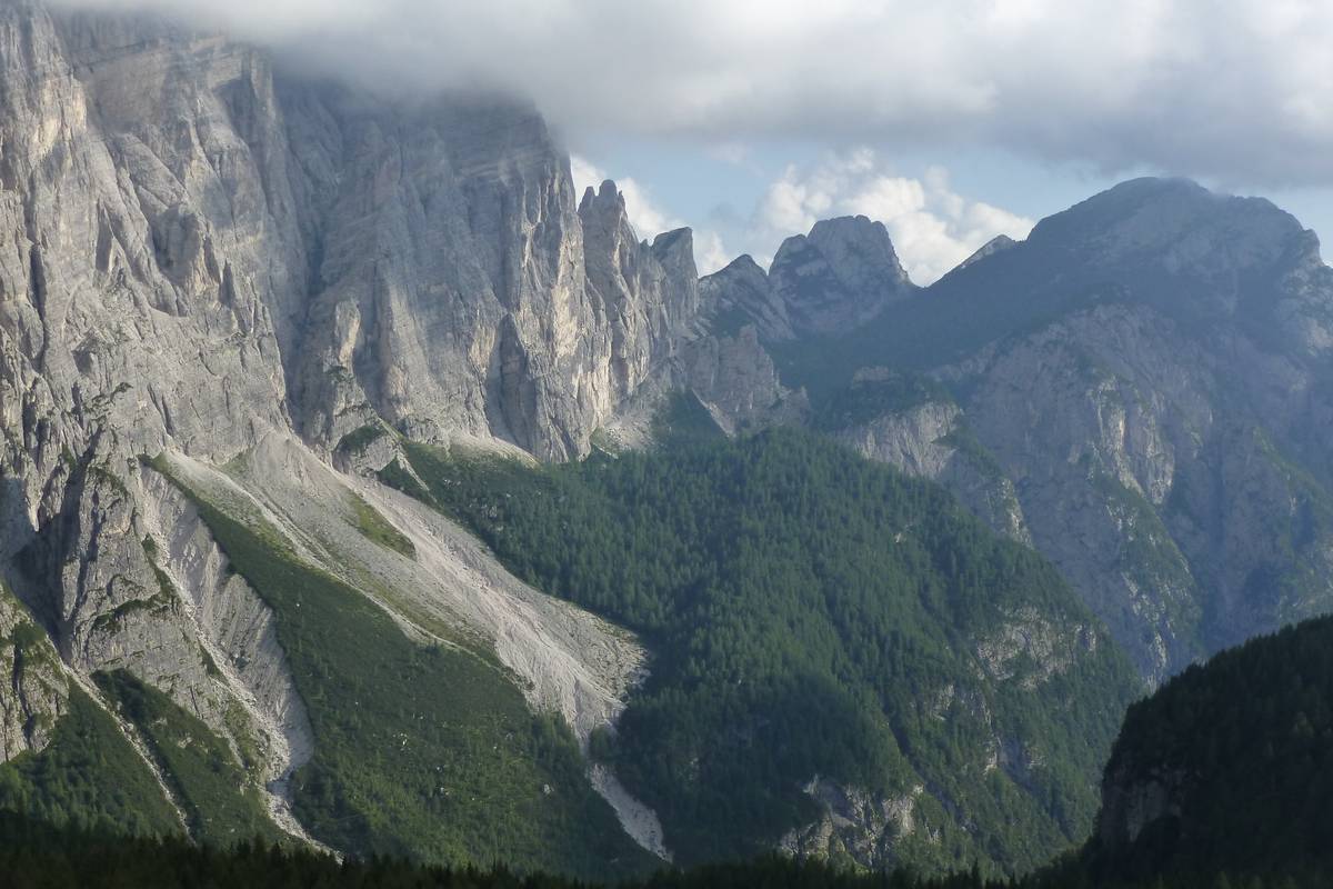
Val Corpassa, Agnér and Cantoni di Pelsa
From the “Mussaia”, you can see the U-shaped glacial valley profile of the Val Corpassa with the left side occupied by the huge detrital stratum developed at the base of the Moiazza and affected by showy debris flow phenomena.
Mount Agnèr (2878 m) dominates the southern horizon. The inclined arrangement of its layers is original and not due to tectonic movements. The Agnèr is, in fact, sculpted in the clinostratifications of the cliff escarpment (Sciliar Formation) of the Pale di San Martino-San Lucano. Further away, on the left, you can see the Cimonega Group with the Peaks of Piz de Mez, Sass de Mura, and Piz de Sagron. To the north, you can see Torre Trieste with its vertical wall.
Continuing the journey, you reach Pian delle Taie (approx. 1600 a.s.l.): from here, you can see the articulated skyline of the Cantoni di Pelsa, an intricate labyrinth of towers, spires, and pinnacles that ends in the west with Torre Venezia.
This type of landscape is produced by selective erosion that actively acts along the weak surfaces (faults and fractures with a prevalent vertical development that cut out and cross the mountain) and spares the areas of more compact rock where towers and pinnacles develop.
Vazzoler Refuge (1713 m a.s.l.)
Owned by the CAI di Conegliano, it rises on the Col Negro di Pelsa (1720 m a.s.l.), at the edge of the coniferous forest, and is overlooked by Torre Venezia.
Next to the refuge, there is a “Botanical Garden” inaugurated in 1968 and dedicated to Antonio Segni (President of the Republic from 1962 to 1964) over an area of about 5000 square meters. The garden is home to about 180 plant species typical of the mountain environment and is divided into two sections: the first one is left to natural evolution, while the second one offers a review of the main Alpine and Dolomite environments.
From the Vazzoler refuge the view extends from Torre Venezia, to the Cantoni di Pelsa separated from the Cantoni Valley by the Cima della Busazza. From here, the view on the famous east face of Torre Trieste is complete. Further to the right, you can see the Cima delle Sasse and all the peaks of the Moiazza group up to the Cima delle Nevère. A further peculiarity of the Civetta group is visible on the Cima delle Sasse.
The thrust of the Cima delle Sasse
In the Trias, with the beginning of the fragmentation of Pangea, relaxing tectonic conditions were established in our region: first emerged the Trentino Platform and Belluno Basin and then the slow sinking allowed the deposition of a considerable pile of sediments in the Jurassic and Lower Cretaceous.
In the upper Cretaceous, the movements of the plates underwent a radical change, while the African plate began its journey towards Europe, producing the compressive conditions responsible for the Alpine Orogeny, which still involves the Alps and Prealps of Belluno.
The first phase of orogenesis (Eoalpina) did not directly affect our region. Studies carried out in neighboring areas have revealed that, in this phase, the subduction and total consumption of a small oceanic branch of the Tethys (the Ligurian Ocean) took place, with the formation of a volcanic arc, a geological situation in some ways similar to the mountain range of the Andes but of much smaller dimensions.
In the Eocene and the lower Oligocene, the Dolomite region (not involved in the first phase of Alpine Orogenesis and still submerged by the sea) was subjected to a compression developed in an East-West direction (Mesoalpine or Dinaric phase), which led to the development of folds and large overthrusts that concerned only the sedimentary cover without involving the Crystalline Base. The remains of these structures, called covering strips, are distributed over some Dolomite groups. Once upon a time, the presence of anomalous masses with discordant layers on the top of the mountains had given rise to the curious name of “peak thrust”. Now we know that, in reality, these anomalous masses, formed by twisted and discordant layers concerning the underlying layers, are nothing more than what remains of large blankets almost completely dismantled by erosion.
The Civetta-Moiazza is one of the areas of the Dolomites where you can observe these thrusts, the most representative area being the Cima delle Sasse characterized by twisted stratifications of Gray Limestones that rest with tectonic contact on undisturbed layers of the same formation.
Boulders with megalodons: Travenanzes Formation and Main Dolomia, Torre Venezia landslide
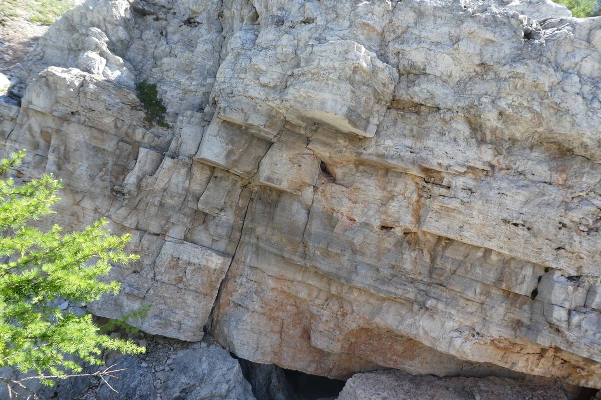
At the base of Torre Venezia emerges the passage between the Travenanzes Formation (Upper Carnic) and the Main Dolomia (Norico), the rock of which the “fossil-filled” boulders next to the path are composed. The enormous shapeless ruins of landslides with large boulders were formed following a collapse that in 1917 affected the western flank of Torre Venezia.
The passage between the two formations is transitional: at the bottom, the arenaceous-marly layers with characteristic reddish hues prevail, then their thickness and frequency decrease in favor of yellowish carbonate lithotypes characterized by stromatolitic but still subtly stratified laminations. The Main Dolomia begins with the first massive bank of intertidal stromatolitic dolomites. The Travenanzes Formation emerges sporadically at the base of the slope all around the Civetta Moiazza group because it is covered by an extensive detrital stratum produced by the gelling processes of the overlying dolomites.
The Travenanzes Formation (Raibl degli Autori Formation) was recently established, and, at the moment, there is still no type section worthy of representing it completely. The formation presents an extreme variability both with regards to the lithological composition and the thicknesses. It is certainly a series of strata in which the transition between an emerged area located south of the Dolomites and the northern area of a deeper marine environment is recorded.
In the southern areas of the Dolomites near the Valsugana Line, which probably served as a geographical limit at that time, you can observe rocks of a continental environment.
In the Civetta-Moiazza Group, the Travenanzes Formation is characterized by the prevalence of dark red clay, sometimes purple, greenish or gray, interspersed with lighter and slower arenaceous layers of conglomerates rich in small colored siliceous pebbles: red, black, and white. Towards the top, carbonate lithotypes prevail with limestone and stromatolitic dolomites. The siliceous pebbles coming from the erosion of porphyry and rocks of the Crystalline Base are rounded and smooth and, since the silica in the Mohs scale has hardness 7, it is clear that to be blunt they must have undergone a long transport by the rivers, before deposition on the seabed.
The “layers of Raibl” are very important from a morphogenetic point of view because they constitute the soft foundation that undermines the overlying Dolomia Principal walls at the base, triggering landslides that cause the walls to retract while maintaining their verticality.
In the upper Trias, the Dolomite region was part of an enormous tidal plain on which the carbonate muds were deposited (from them, the Main Dolomia originated). The uniformity of the sedimentation environment masks the effects of synsedimentary tectonics, but, observing the thickness and distribution of the Main Dolomia, it emerges that even during the Upper Trias the region presented a certain degree of instability. In the Civetta-Pelmo area, the subsidence was moderate, about 300-400 meters of dolomite deposited, 600 meters on the Antelao, and more than a thousand on the Tofane.
We can divide the Main Dolomia into two parts.
The lower part is the “typical” of the formation: each layer from 1 to 2 meters thick is delimited by erosion surfaces related to the emergence and reprocessing of previously deposited sediments by waves and tides. Much of the layer was formed in intertidal conditions (between high and low tide) and is characterized by a dense horizontal lamination: these are stromatolitic sheets generated by blue algae which, during high tides, covered the seabed with real carpets, trapping and retaining the fine carbonate mud deposited by the waves during hurricanes. With low tides, the emerged seabed (exposed to the hot tropical sun), dried out, giving rise to polygonal muds, still recognizable on layer surfaces. In reality, it is not possible to distinguish the daily phases of the tidal cycle in the rock; rather, we should use the term “intertidal” to indicate short-term fluctuations (a few years) due to astronomical or meteorological causes.
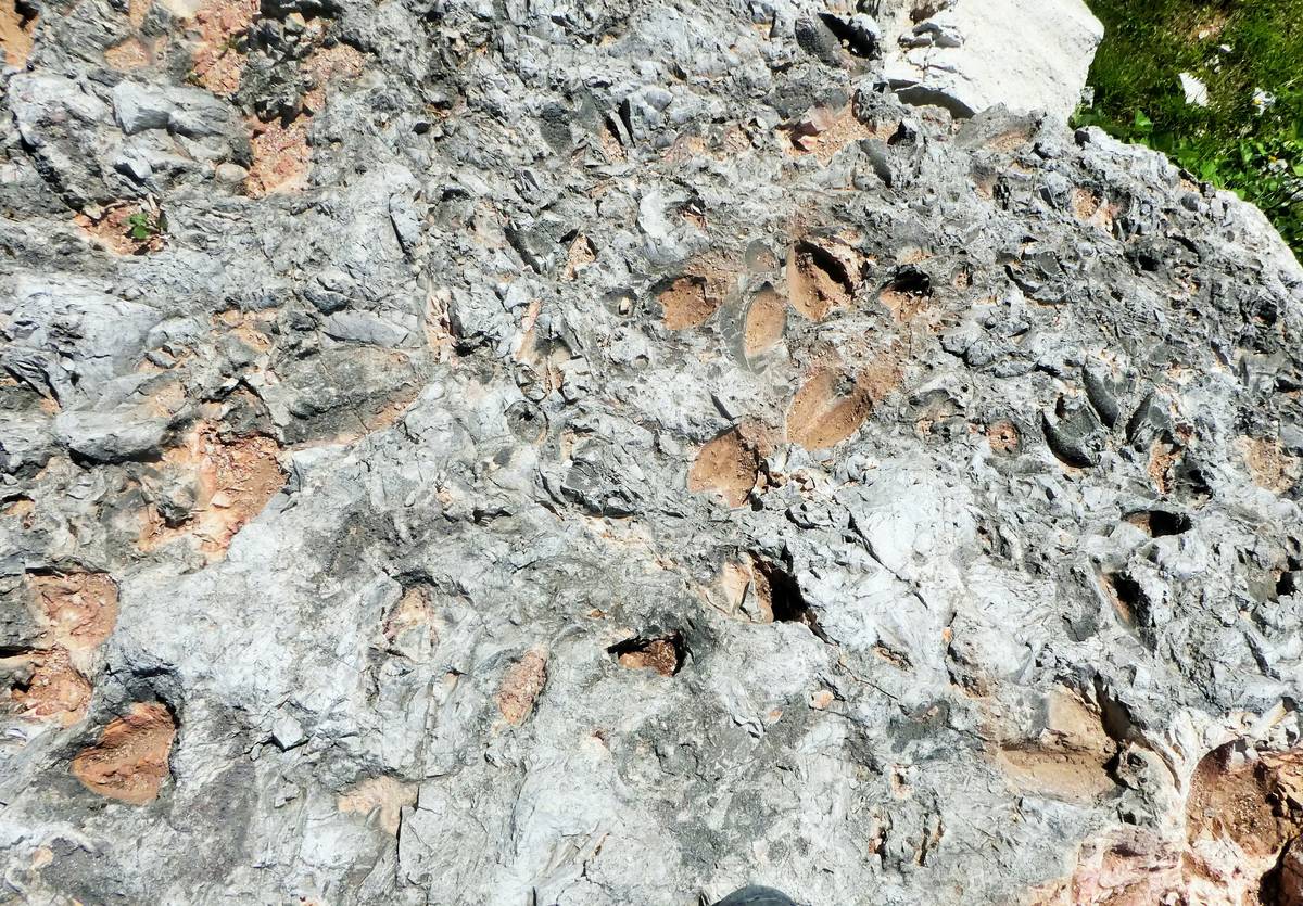
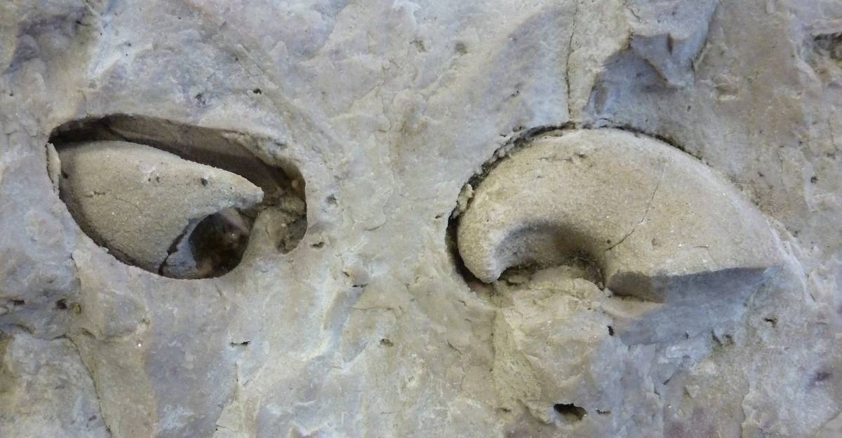
The lower or intermediate part of the strata is usually composed of compact and vacuolar dolomites formed in subtidal conditions; they contain fossil remains of gastropods (Worthenie) and bivalves (Megalodon) in the form of internal models. This method of fossilization generally creates specimens poorly preserved from a paleontological point of view but, at the same time, particularly aesthetically beautiful due to the presence of the shiny rhombohedral crystals of dolomite that cover them. The megalodons were mollusks that, to be able to live in this inhospitable environment (they were constantly swept by strong tidal currents), had developed a robust and heavy shell, equipped with hooked or helix-shaped plates with which to anchor to the muddy bottom. The particular concentration of shells on the surfaces of these blocks can be related to the action of waves caused by hurricanes. Each layer is the product of the sedimentation that took place between a phase of rising (transgression) and a phase of lowering of the sea level (regression): it is a cycle that in the development of the formation is repeated hundreds of times and is indicated with the term cyclothymic.
The Legend: the “Anguane”, in the Ladin tradition, are mythological beings guardians of the waters and springs; they have the appearance of beautiful women but do not have human feet but legs similar to those of goats. This legend likely arises from the observation in the layers of Dolomia (Cassiana and Principale) and of Gray Limestones of the footprints of megalodons that look like petrified footprints left by artiodactyl mammals such as goats, deer, and chamois.
The upper part, instead, is the result of poorly stratified saccharoidal dolomites interspersed with pisolite pedogenetic levels (granules formed by concentric shells of calcium carbonate) and gray bituminous dolomites with carbonaceous frustules (small plant fragments). The “teepees” recognizable in the layers as arched laminae to form a kind of Indian tent a few tens of centimeters high are formed in this way: on the shallow seabed, the muddy deposits are subjected to premature cementation by precipitation of carbonates. The crystallization of the cement induces a swelling with arching and fracturing of the already consolidated mud, then the fractures are immediately filled by the still soft mud above and, subsequently, undergo the definitive cementation.
Due to the presence of these particular sedimentary structures, the upper part has been interpreted as a subaerial modification of sediments deposited in the subtidal environment, which emerged due to eustatic fluctuations in the sea level.
The Main Dolomia ends with a series of more erodible layers on which discontinuous inclined ledges develop, a characteristic which, together with color variations, makes it possible to distinguish it from the overlying Gray Limestones.
Col del Camp (1843 m a.s.l.) – Dolomia Cassiana
From the bend where the road leading to Case Favretti branches off, we are within sight of the Col del Camp (privately owned like the rest of the surrounding area) and of Torre Venezia, with the detachment niche of the landslide that caused hit in, in November 1917 and more recently in 2020.
The scenario on the Civetta-Moiazza group, in the Cantoni del Framont area, is particularly interesting because it allows us to identify very well the step that divides the upper building (of Main Dolomite and Gray Limestone) from the lower one (cliff dolomite). The Framont consists almost entirely of the Sciliar Formation (on its left flank) and the Cassian Dolomite emerges on the Corno del Framont. Due to the easy erodebility of this slope interruption, the Travenanzes Formation is almost completely buried under the detrital strata.

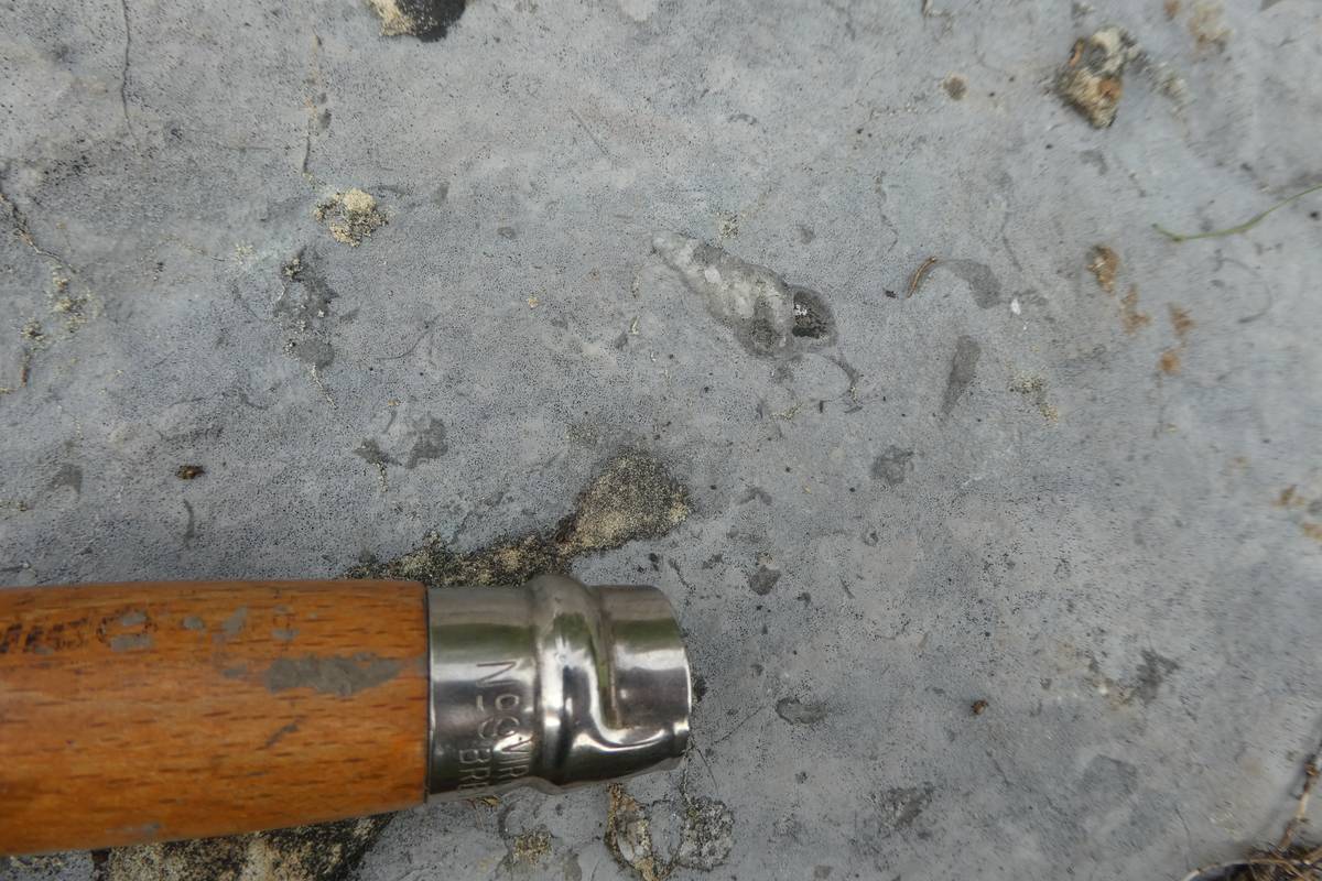
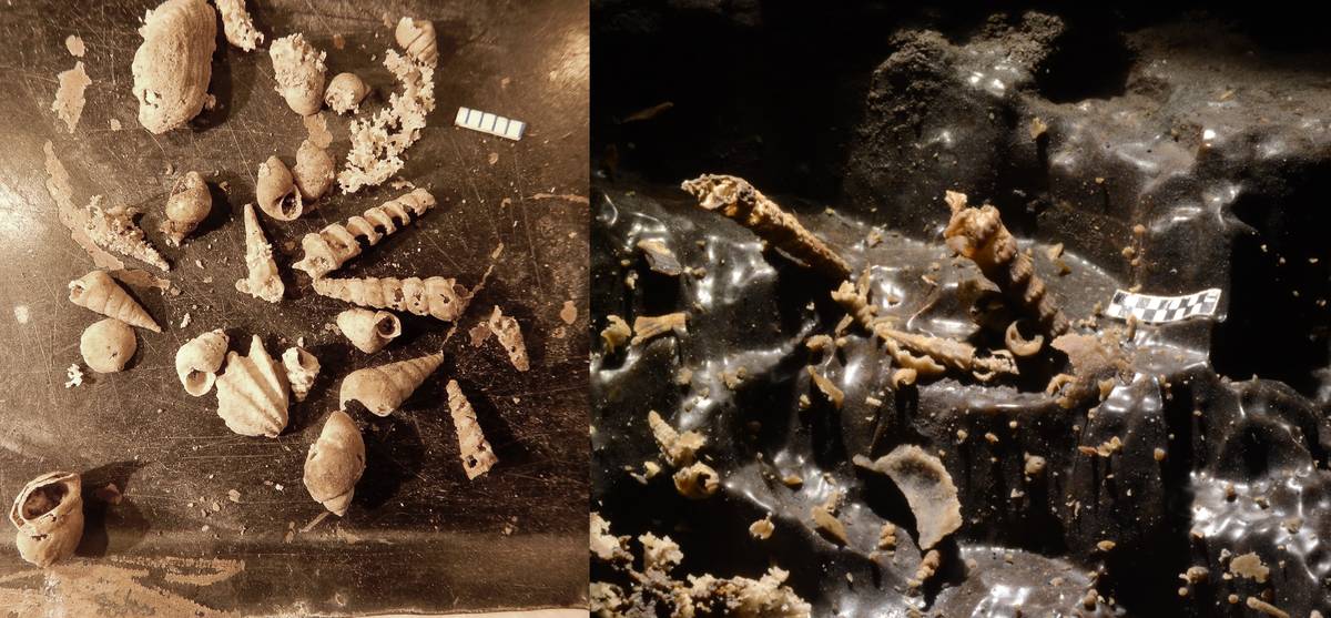
In this area, limestone layers of a light gray or pink color emerge, sometimes with a slightly nodular appearance and rather rich in fossils. By observing with a little attention the surface of these layers, washed away by karst, it will not be difficult to identify typically spiral sections of gastropod mollusks, shells of bivalve mollusks, calcite crystals formed by articles of crinoids deriving from the disintegration of sea lilies and, sometimes, even some tufts of corals.
These are layers deposited in the internal lagoon environment of the Cassian cliff, characterized – unlike the Ladin platforms – by a low upward growth (aggradation), due to the low rate of subsidence of the Dolomite region during its sedimentation.
The journey continues towards Malga Pelsa: almost immediately you can feel that something is changing in the geological substrate because the pink limestones are replaced by bituminous limestone, subtly stratified.
Malga Pelsa (1829 m a.s.l.) and Pelsa lagoon
You can reach Malga Pelsa (Casera di Pelsa, 1829 m asl) in just over half an hour from the Vazzoler refuge. It is located at a slope interruption of the side, between the underlying dolomitic rocks of the Sciliar formations and the Cassian Dolomite landslide of Monte Alto di Pelsa.
The Pelsa lagoon
In the Carnian (236 million years ago), following a new sea-level rise, the Dolomite region found itself again in conditions suitable for the growth of organogenic cliffs. New communities formed this time mainly by corals with sponges and algae, began to proliferate in various areas of the Dolomites. However, these cliffs (from which the Cassian Dolomite originated) developed in a tectonic context different from the previous ones with a rate of subsidence much lower than that which had characterized the Ladinian. As a consequence, they grew more laterally (progradation) than upwards (aggradation), assuming the appearance of a coral reef that progressively advanced on the surrounding basins filling them.
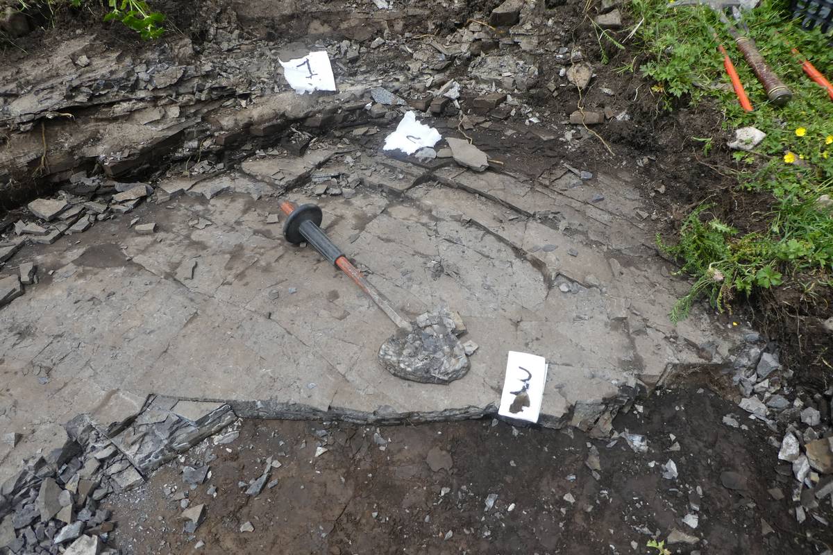
In the Civetta area (Col Rean, Coldai, Corno del Framont), the Cassian Dolomite, with its modest thickness, rests directly on the Sciliar Formation, but in a small area, limited to the Monte Pelsa spot: the contact takes place with a pack of layers of thinly stratified bituminous limestones, dark gray, smelly to percussion. These discontinuous layers were described in the post-war period by the geologist Bruno Castiglioni who explored every corner of the Agorder Dolomites, defining the stratigraphy, tectonics, and geomorphology of the Pale di San Martino and Civetta-Moiazza groups.
These levels – unique in the Dolomites – settled at the end of the Ladinian period, simultaneously with volcanism, in a small lagoon developed within the internal platform characterized by poor water circulation. This led to the formation of anoxic layers.
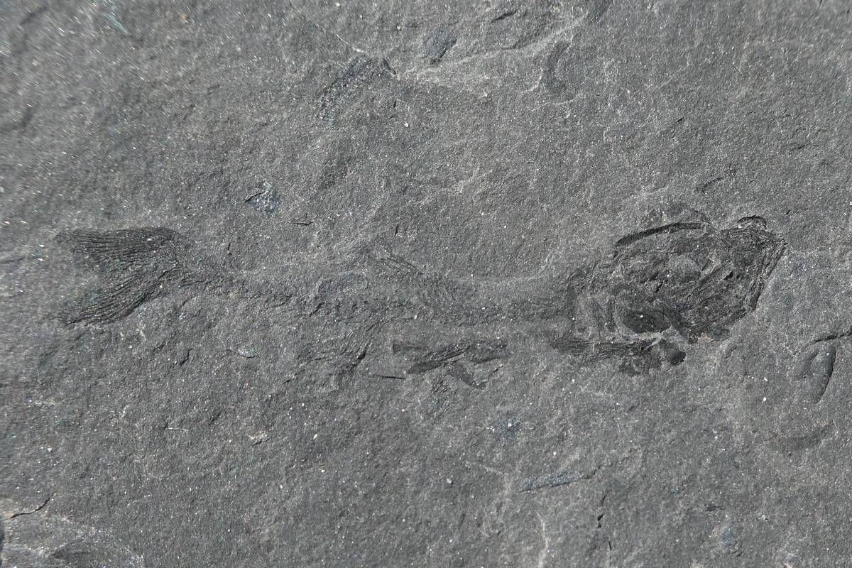
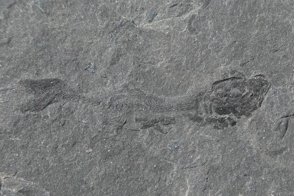
The anoxic character of the layers identified by Castiglioni in the Pelsa area makes them a potential mother rock of oil, which prompted Professor Maurizio Gaetani, a paleontologist at the University of Milan, to study the area with his graduate student, Andrea Tintori, who had to deal with fossil fish. As part of the research, some remains of fish and an insect were found and they discovered that there were two anoxic basins: one to the east of the Col delle Capre, in the area of Malga Pelsa, and one to the west, above the locality of Barancion.

Time passes (there is no oil), and Andrea Tintori becomes a professor of paleontology and specialist in Triassic fossil fish. His studies initially turned to Lombardy (Orobic Prealps, Grigne, Monte San Giorgio) and Carnia and, in a second moment, to South China.
It was in China that the remains of the oldest flying fish in the world (Thoracopterus wushaensis) came to light during the systematic excavation of a large surface of a fossil level of the Ladinian period (specially prepared by local authorities to extract fossil fish and reptiles).
The new species, defined and studied by Professor Tintori (2012), is characterized by a relatively large field of small sub-square scales immediately behind the skull and another supporting the ventral lobe of the caudal. The scales of the dorsal-thoracic region have the surface decorated with thin and short striae.
The Chinese deposit in which many other species of fish (including several new species), reptiles, and other fossil remains (including ammonites) have been collected, has already become a tourist destination with an attached paleontological museum.
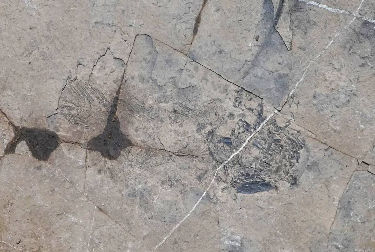
In light of Chinese discoveries, Professor Tintori – now close to retirement – returns to the materials collected, as a young paleontologist, on Monte Pelsa, supposedly contemporary, by stratigraphic position, with the Chinese strata, and decides to resume research in the countryside. Already at a first taste, the results are truly surprising: from blocks scattered on the surface, extracted and exposed in a modest hole, produced during the renovation of the huts, Prof. Tintori identifies precisely the remains of Thoracopterus wushaensis. This discovery alone would be enough to shout for the great discovery, but, on the same day, at least 6 other species of fish are found, as well as structured plant remains, bivalves, gastropods, cephalopods, and corals.
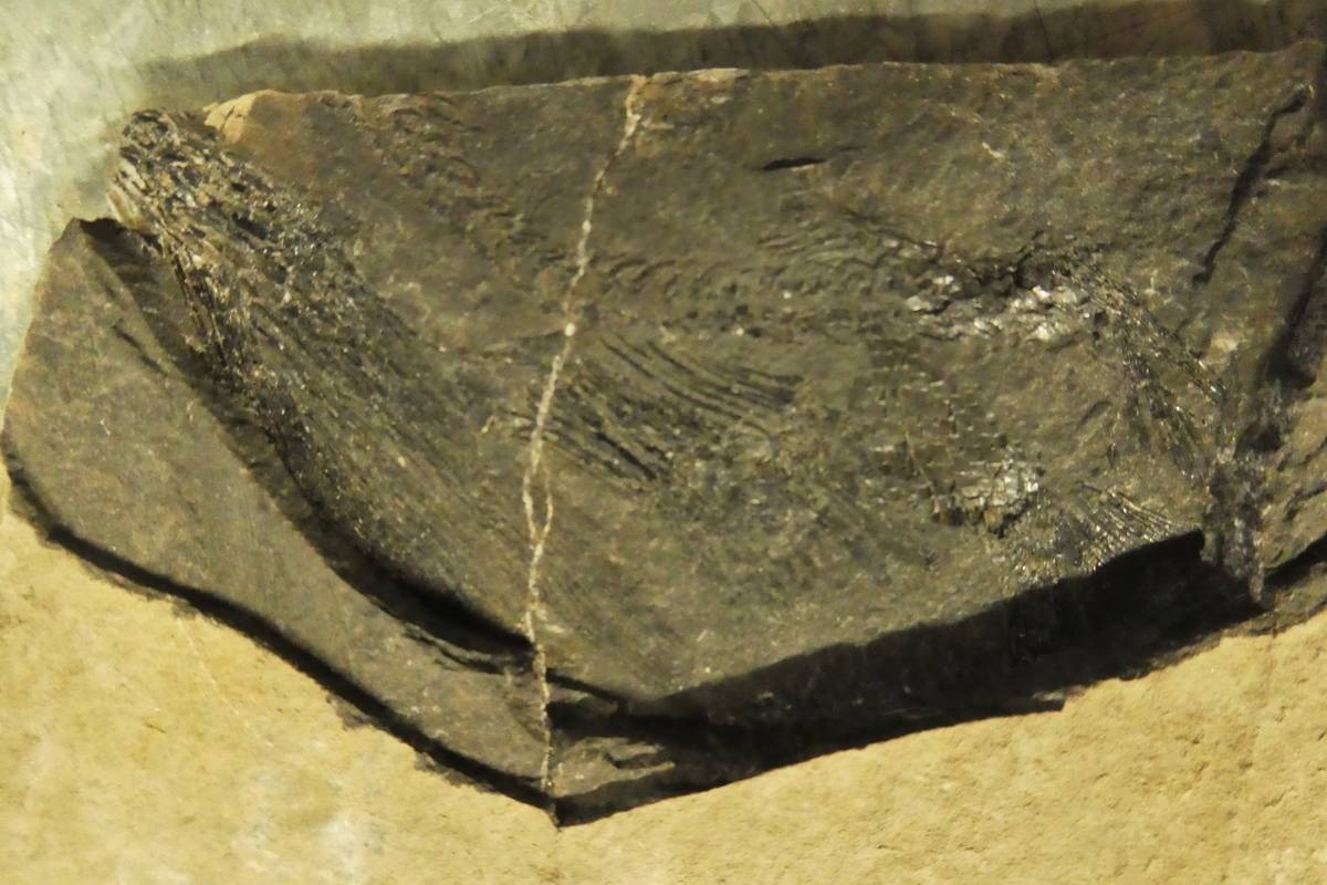
Furthermore, some carbonate blocks, dissolved in acetic acid, have released a world of silicified fossils. We’re talking about an important discovery: the first case of silicified fauna in the entire Alpine Triassic and one of the very few in the world for this time interval, perhaps the last case of mass silicization of carbonate fossils in the history of the Earth. The cause of this silicization could be linked to the Upper Ladinian volcanism, which introduced large quantities of silica into marine waters.
And so after some other superficial “tastings” in the area, which continue to confirm the importance of the site, at the end of 2017, more systematic research is carried out with the permission of the Superintendency of the Veneto Region; it continued in September 2018, involving also the IIS Geotechnical Mining “U. Follador” of Agordo.
During the excavations, they found well over 100 fossil fish with different species, including numerous specimens of Marcopoloichthys and Habroichthys, represented here by a new species, the most recent of the genus. They found a specimen of Placopleurus, a fish so far known only up to the lower Ladinian, and the remains of Saurichthys. These predatory fish are similar to the current barracuda and have a very rare shark fin. In all the Alps, only one other specimen has been found, coming from the famous deposit Monte San Giorgio on the border between Italy and Switzerland, another UNESCO World Heritage Site.
In addition to a specimen of coelacanth, in the same layers, they found ammonites of the Protrachyceras Archelaus species, a guide fossil that allows them to be attributed to an Upper Ladinian age. This is also an exceptional fact because it will allow us to correlate the ammonite faunas of China (that are completely different from the Alpine ones) with the contemporary ones of the Alps, thanks to the presence of the same fish, which are much faster than the ammonites to move in the ancient Ocean of the Tethys.